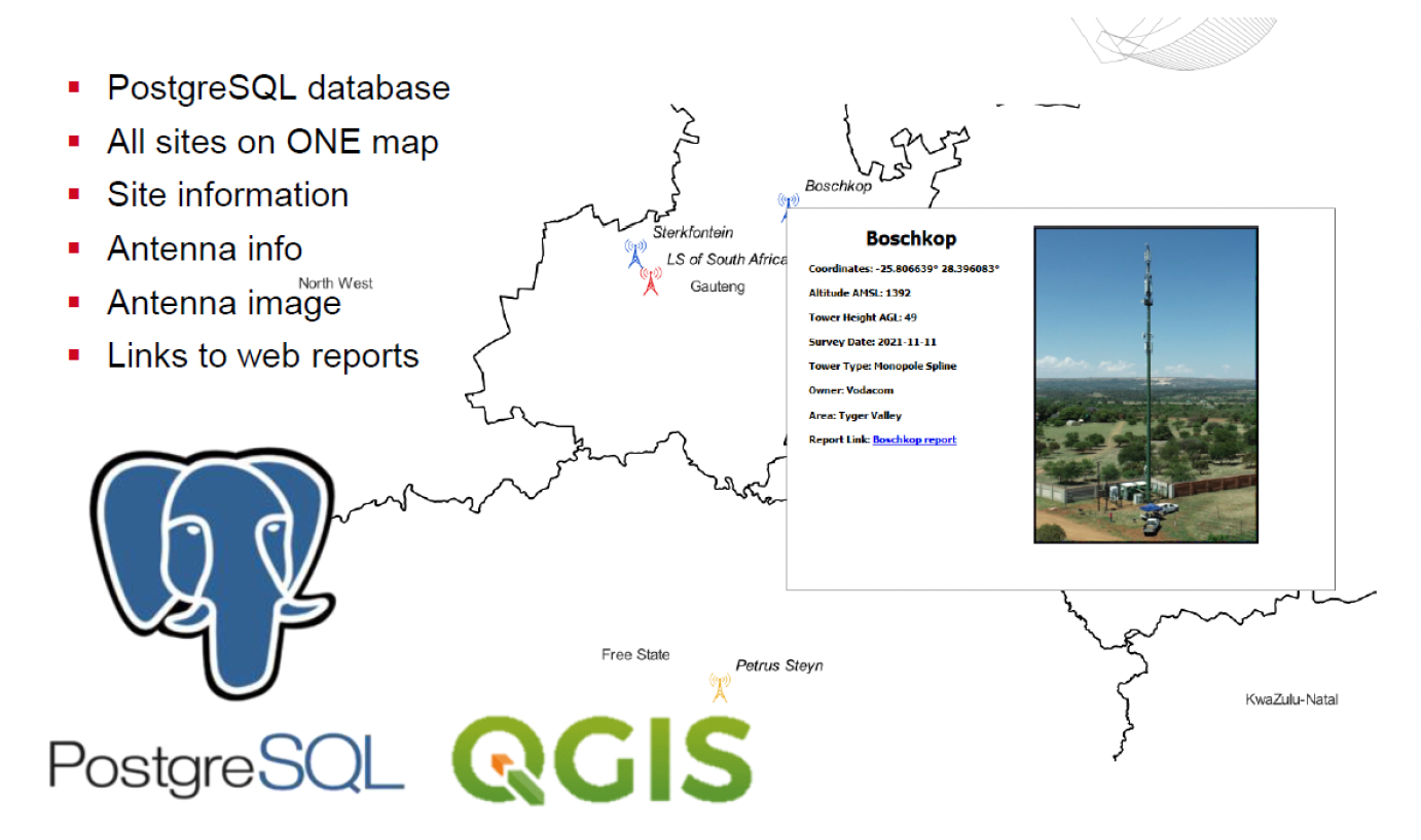
OUR SERVICES
RPAS
Mapping and surveying
Airborne mapping/surveying
Flight data acquisition for aerial mapping and surveying is done through the recording of high resolution geotagged images for photogrammetric modelling. Accurately placed ground reference points and check point are deployed as required.
This processed data can be applied for the visualization of a wide range of applications or representations in two or three dimensional models/point clouds in various formats and at various resolution levels.
This process can be complimented by various added scanned datasets either ground based or airborne (application dependent)
Outputs include:
- 3D terrain models (surveyor resolution if required)
- Ortho maps/contouring
- DEM’s
- Stockpile management
- Extraction pits and dumps
- Slope inspection/slip hazards
- Dam tailings
- 3D modelling and visual inspection from all angles
- Road mapping and inspection
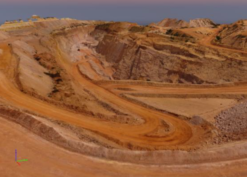
Scaled, fully constructed, 3D terrain of quarry surveyed area
Mobile site audits
Deliverables:
LSMC provides an advanced Remotely Piloted Aircraft (system enabling a full mobile site audit that supports: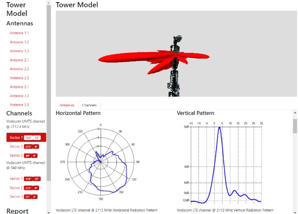
- A spectrum scan displaying active channels
- Detailed information of individual channels based on the National Radio Frequency Plan Band Plans (Service Provider frequency, bandwidth, and technology type)
- A display of the radiation pattern of each individual transmitting channel (Vertical pattern, Horizontal pattern, and 3D representation)
- Technical specifications of the channel transmission (Effective Radiated Power (ERP) and bandwidth)
- Highly accurate positioning of individual antennas mounted on the mobile tower/mast
- Antenna characteristics: Centre of Radiation (CoR), Height Above Ground Level, Antenna Width, Antenna Length, Electrical tilt and Mechanical tilt.
- A list of the channels being transmitted from each individual antenna
- A scaled model of the mast for mechanical and civil analysis
- 3D viewer of the mast with integrated RF patterns and information for client-side analysis
Site Inspections
Site Modelling and Visual Data Capture (including Mobile radio and broadcast site auditing)
LSMC offers a 3D modelling service whereby the site infrastructure is rendered and represented using photogrammetry. High resolution photographs of all site and mast elements are available for any portion of the 3 D model of the site and this allows the customer to “virtually” scrutinize the 3D rendered model in the comfort of his office. This service is particularly suited for the determination of installation quality, operational integrity and rental capacity on mast structures and sites. Site element dimensions and spatial positions can also be accurately determined.
The service is also offered in synergy with LS’s spectral measurement airborne services.
Recordings can be done of equipment mounted on the mast, the site layout and for the various site services such as power line routes and roads. Deliverables might be outputted in various formats.
Such records are extremely valuable for both infrastructural -, operational -, and audit purposes.
Examples of site elements that might be included in the modelling procedure are:
- Mast occupancy (antenna count)
- Site occupancy (buildings, containers structures satellite antennas)
- Site grounds conditions (crush stone, weeds, erosion, etc.)
- Mast condition (rust, wind damage, loose attachments, access doors, cables and cable trays, etc.)
- Security perimeter fence and gate (rust, compromised, etc.)
- Immediate adjoining environment (houses, veld, farm land, etc.)
- Access road, drainage, slopes, volumes, and areas.
Outcomes of site modelling and visual data capture
- A detailed, scaled (as required) model of a site, enabling the assessment/condition of all elements on the site. In case of telecommunication sites components such as mast occupancy /mast components / mast condition /antennas and cable installations can be scrutinized.
- From the constructed scaled model it is also possible to determine physical dimension measurements and volume calculations of any objects on and around the site.
- Highly -detailed, geo-referenced aerial imagery can be compiled of the site and surroundings.
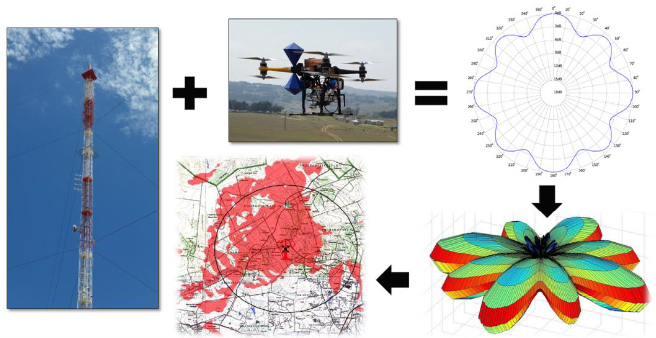
Broadcast service site RF Characterisation
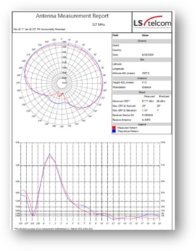
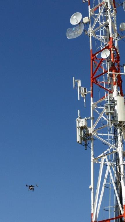
LSMC offers its RF antenna measurement services to network operators and regulatory authorities to efficiently determine the on-site performance of complex radiating antennas and without imposing on the actual operation of broadcast services.
The Remote Piloted Aircraft measures the radiation pattern in the horizontal and vertical planes at predetermined altitudes and distances from the antenna.
The deliverables per transmission service consist of spatially quantified:
- Horizontal radiation patterns (HRP)
- Vertical radiation patterns (VRP)
- Effective radiated power (ERP) and
- Associated derived parameters (mechanical and electrical tilts, null-fill, etc.)
RF SERVICES
RF SERVICES
Broadcast service site RF Characterisation
LSMC offers its RF antenna measurement services to network operators and regulatory authorities to efficiently determine the on-site performance of complex radiating antennas and without imposing on the actual operation of broadcast services.
The Remote Piloted Aircraft measures the radiation pattern in the horizontal and vertical planes at predetermined altitudes and distances from the antenna.
The deliverables per transmission service consist of spatially quantified:
- Horizontal radiation patterns (HRP)
- Vertical radiation patterns (VRP)
- Effective radiated power (ERP) and
- Associated derived parameters (mechanical and electrical tilts, null-fill, etc.)
Antenna elevation & azimuth pattern and ERP measurements
RF spectrum scans
LSMC offers a very useful RF scan service in conjunction with its antenna radiation measurements whereby the actual on-site channel utilization in bands of interest is determined.
RF radiation generated by airborne vehicle
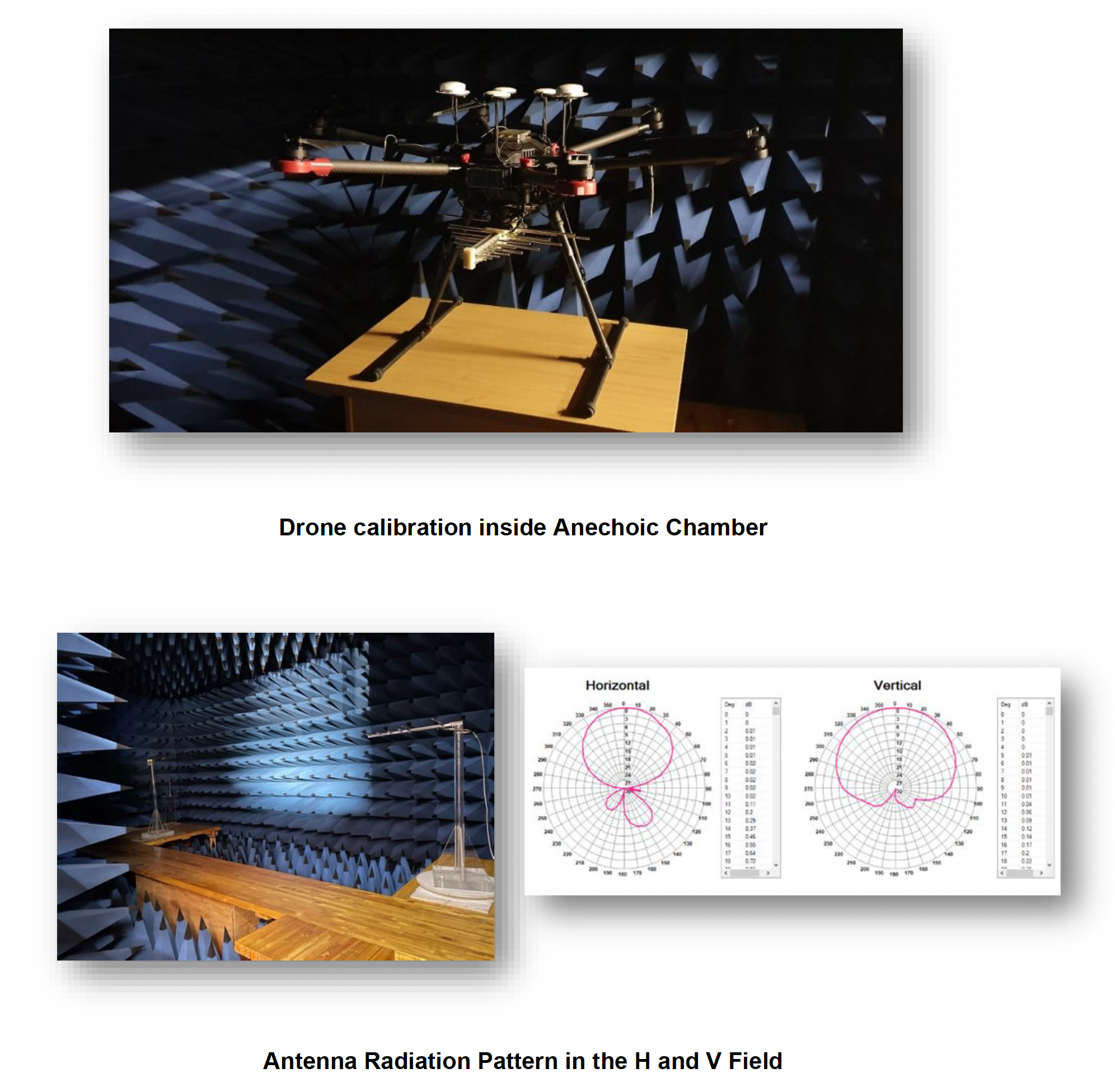
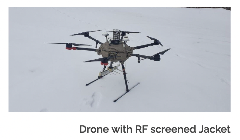 The measurement vehicle is a crucial component in the measurement system. The fact that the measurement system is designed to measure radio frequencies, demand that the vehicle has low levels of RF radiations. At the same time, it is also crucial that the user of the vehicle is well aware of the RF radiation that is generated by the airborne vehicle. For this reason, it is important that the vehicle is analysed in an anechoic chamber to determine the levels of radiation originating from the measurement vehicle. It is also very important to ensure that the measurement vehicle’s RF radiation does not impact on the measurements which is performed on the antenna system.
Complementary RF spectrum measurements/activities (RPAS)
- Propagation model calibration (diffraction losses, morphology classes refinement, Fresnel zone obstruction losses)
- Radiation measurements. [E.g. spectral performance (EMC) of installations/sources]
- Volumetric signal strength measurements within a large three-dimensional space
- Intermodulation studies/levels and harmonic assessments
- Noise level studies within a large three-dimensional space
- Identification of “white space” areas
- Determination of unauthorized transmissions/radiation; Regulatory environment
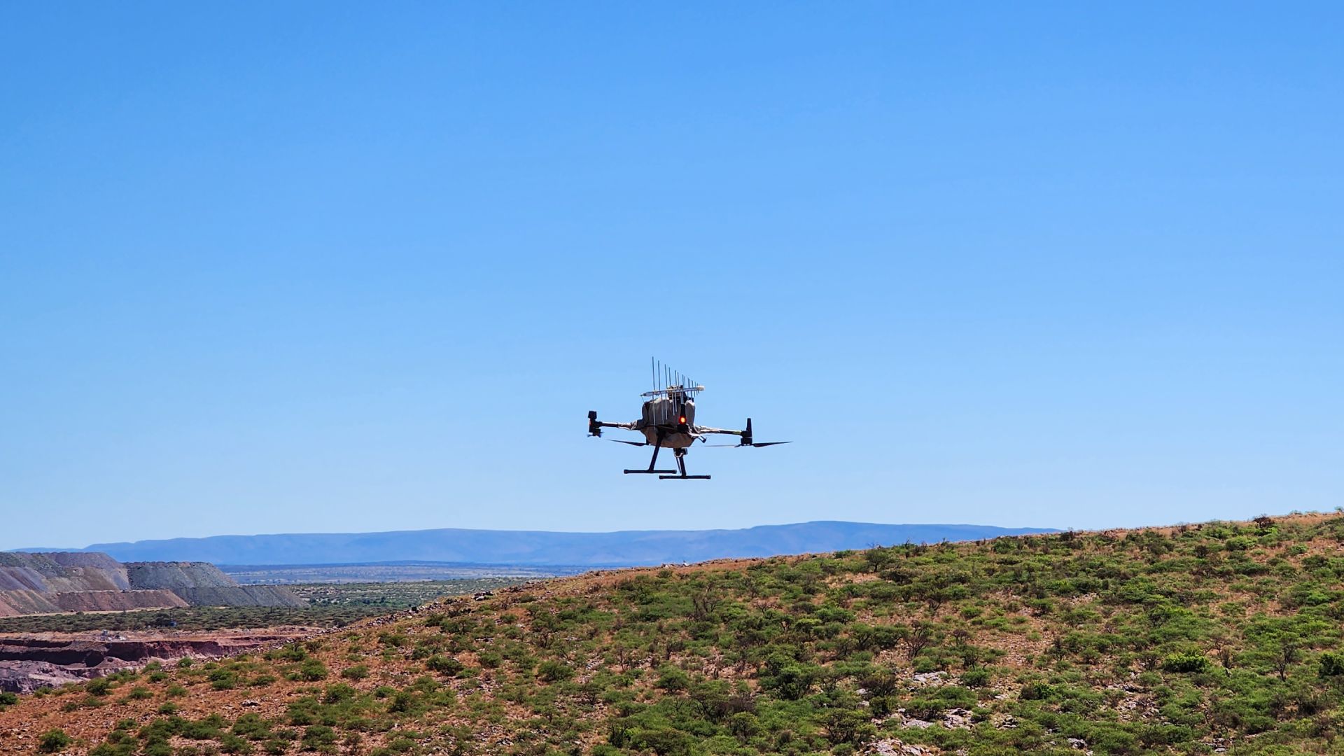
DIRECTION FINDING/INTERFERENCE HUNTING
The method used is based on an Angle-of-Arrival (AoA) direction finding approach.
A general technique called “Angle-of-Arrival (AoA)”, is implemented on an RPAS to be able to track and find a source location of a specified channel. This is to predict possible source of interference locations of channels within a certain measured bandwidth. This is done by doing point rotations at a certain altitude while sweeping through the spectrum.
The figure below displays the typical flight path flown at every measurement location at different vertical heights.
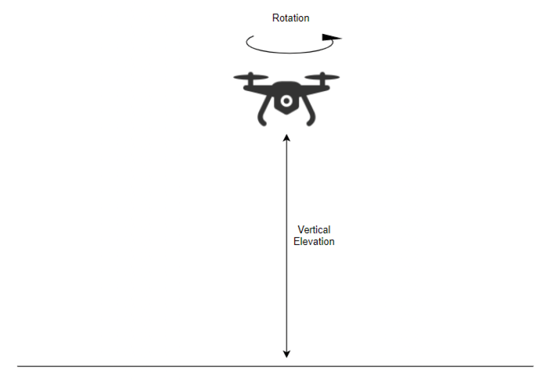
- Define the locations of the measurements.
- Define height of each measurement point using a relative height AMSL (Above Mean Sea Level)
- Setup measurement parameters (Bandwidth, Resolution, Sweep time, Frequency Range…)
- Do a rotational flight on the allocated measurement point at the defined height(s). Multiple rotations allow increased data accuracy
- Post-process measured data
- Calculate the maximum received level vectors for each location and apply applicable filters
- Plot the vectors on a geographical map
- Analyse the data and create the report
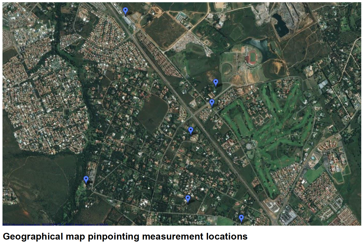
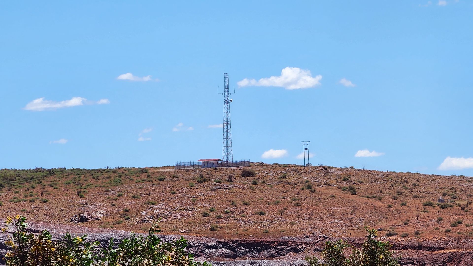
Measurement Location
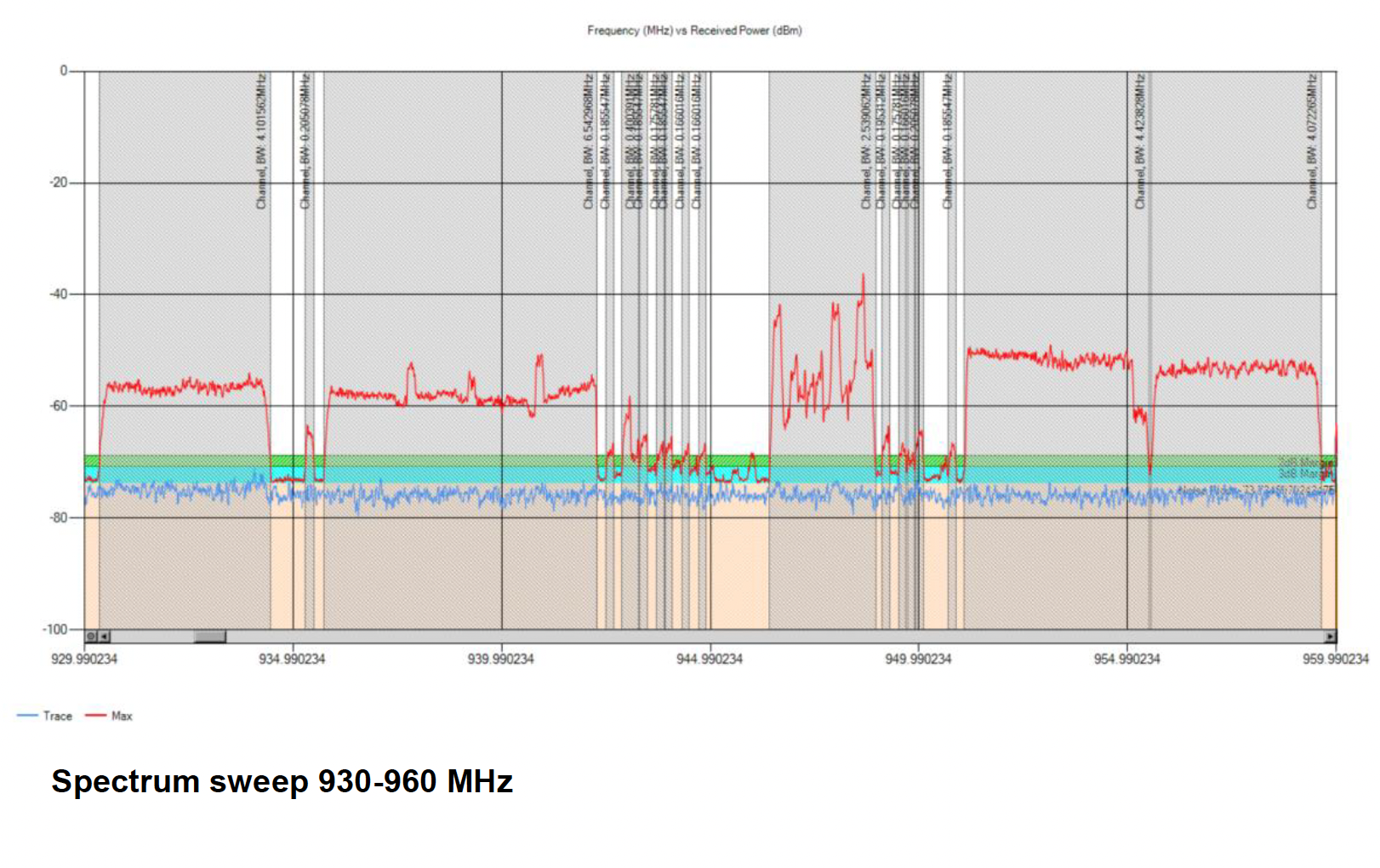
Spectrum Analysis
A spectrum plot is shown, taking the maximum received activity for the whole area into account. The spectrum analysis shows all the active channels and their information.
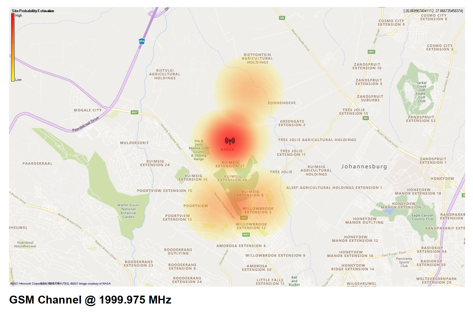
Channel source location predictions
Each result consists of a geographical map, which is overlayed with a scaled heat map. The heat map represents the probability of the channel’s source location. Each detected channel will have a unique source prediction. The Tower marker indicates the most probable position for the tower and the coordinates of the position can be seen in the top right corner.
Conclusion
Using an angle of arrival (AoA) direction finding method, a set of maximum power vectors (discussed above) can be arrived for every channel detected in the spectrum analysis. The vectors are then used to obtain intersection points, which are used to draw a heatmap using a KDE (Kernel Density Estimation) model. The heatmap shows the least probable to the most probable source location of each of the above-mentioned channels.
Using the maximum determined KDE value, an estimated coordinate could be derived showing what the most probable coordinate of the channel source is.
FULL SCALE 3D MODELLING
LSMC offers a 3D modelling service whereby the site infrastructure is rendered and represented using photogrammetry and Lidar. High resolution photographs of all site and mast elements are available for any portion of the 3D model of the site and this allows the customer to “virtually” scrutinize the 3D rendered model in the comfort of their office. This service is particularly suited for the determination of installation quality, operational integrity and rental capacity on mast structures and sites. Site element dimensions and spatial positions can also be accurately determined.
The service is also offered in synergy with LS’s spectral measurement airborne services.
Recordings can be done of equipment mounted on the mast, the site layout and for the various site services such as power line routes and roads.
Jachtfontein 3D-pattern views
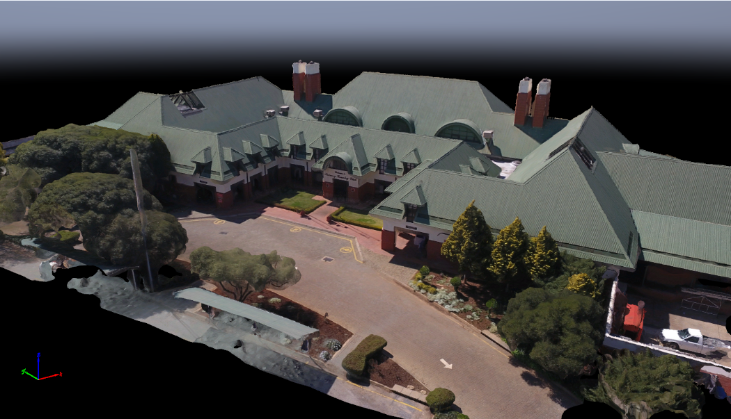
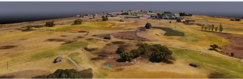
Scaled, fully construction, 3D terrain of surveyed area, with identified reference location markers (example building and golf course)
SATELLITE DISH MEASUREMENTS
By generating a test signal on an RPA system, we can determine performance characteristics on a satellite dish receiver. Flying a grid pattern over the antenna provides enough information to accurately determine:
• Horizontal pattern beam width
• Vertical pattern beam width
• Beam direction
• Maximum receiver gain (includes Theoretical LNB Gain)
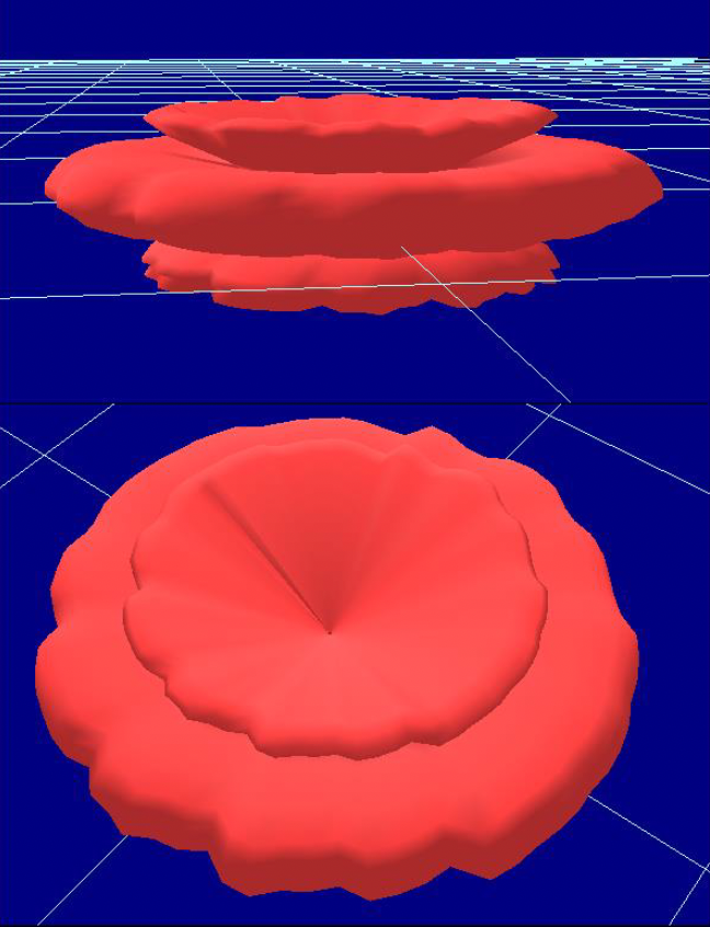
• Three-dimensional representation of the beam
• Polarization discrimination
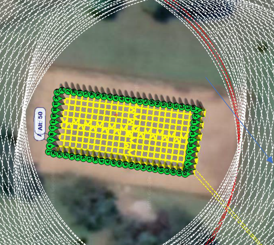
Grid flights over satellite dish receiver with RPAS transmission
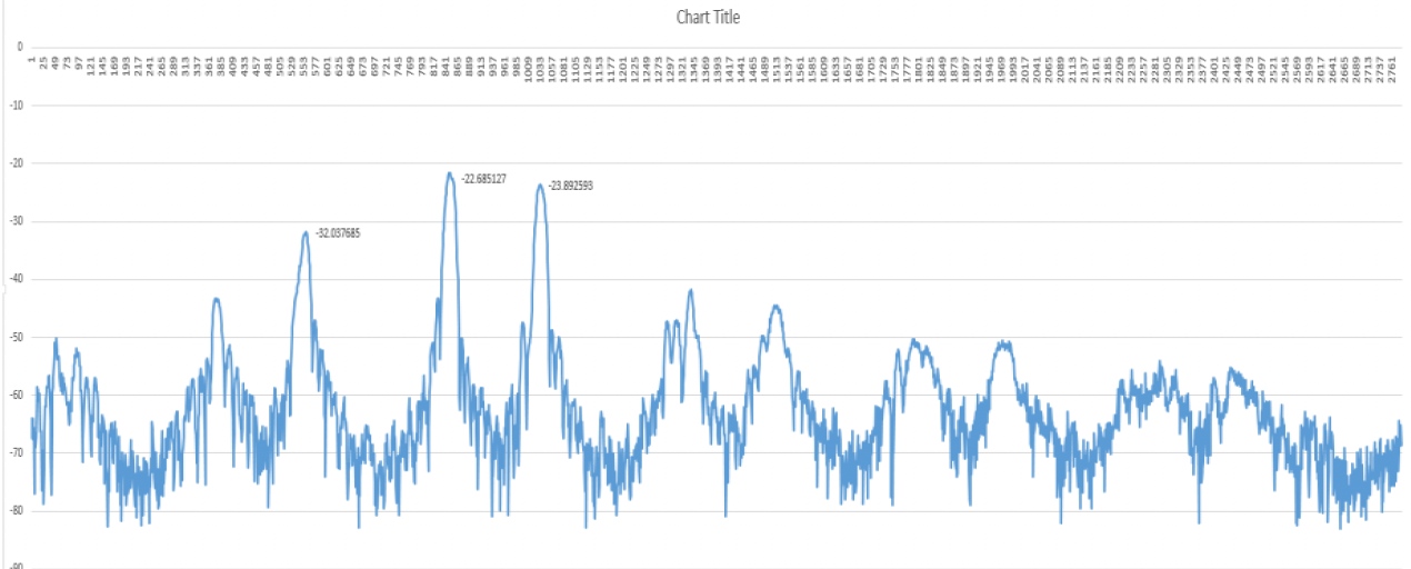
Received power on a single flight line.
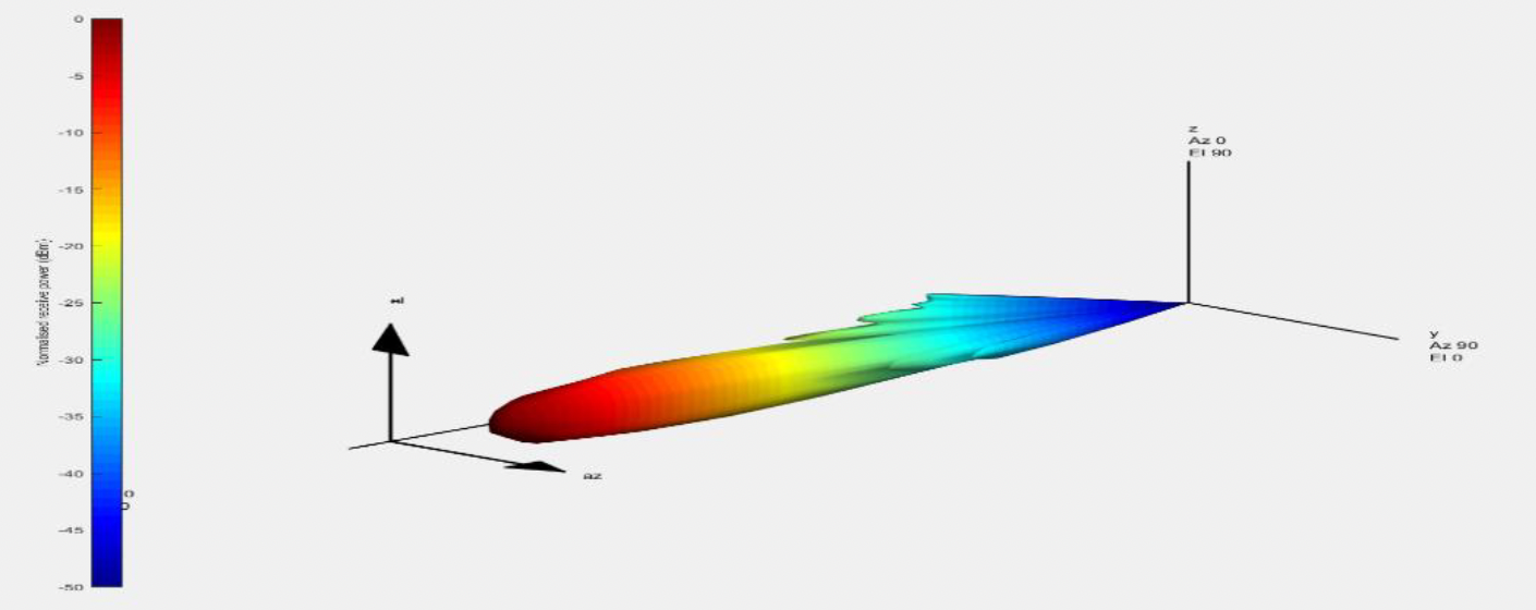
Generated three dimensional radiation pattern of satellite dish receiver.
OTHER SERVICES
ANECHOIC CHAMBER (WITH AUTOMATED MEASUREMENT CAPABILITY AND AUTO REPORT GENERATION)
ANECHOIC CHAMBER (WITH AUTOMATED MEASUREMENT CAPABILITY AND AUTO REPORT GENERATION)
An anechoic chamber is a shielded room that is lined with absorber material such as conductive carbon to inhibit external interference but also eliminate multipath artifacts. This creates an ideal environment for testing electronic devices. Electronic devices must undergo testing at an official certification lab before market launch to ensure regulatory compliance.
We have designed and installed our own anechoic chamber at our head office with a frequency range of 100 MHz to 6 GHz. The chamber is a full chamber that include absorbers on the floor, walls and roof. We intend to extend the frequency range of the anechoic chamber to 30 GHz during the next year to cater for extended frequency usage in higher frequency bands as well as international mobile telecommunication (IMT) equipment operating in higher frequency bands.
Our anechoic chamber is automated to perform 3D analysis in an automated manner with one single measurement computer controlling the measurement device, the signal generator and the turntable. We can measure up to 1 degree accuracy with our turntable and the measurement report generation is automated. Our UAV measurement capability compliments the anechoic chamber as it can instantly be deployed on an open test range to simulate the measurements in the anechoic chamber.
We provide the following services:
• LSMC offers in house Pre-compliance EMC and EMI testing in its Full Anechoic Room to assist device manufacturers in the prototyping stage prior to entering official certification labs for full compliance and approval.
• Antenna testing services to characterize antenna specifications.
• EMC radiated measurements
• EMI immunity measurements
• Antenna pattern and gain characterization
• Out of band measurements
Benefits of using our Anechoic Chamber:
▪ High accuracy of EMC Pre-compliance measurements
▪ Fully lined walls and floor with carbon coated absorber cones eliminates multipath artifacts for accurate characterization of antenna field measurements
▪ Use of Real-Time Spectrum Analyzer and a set of industry approved EMC antennas to obtain representative RF performance
▪ Automated measurement reporting for fast turnaround testing times
▪ A cost-effective way to determine whether your product will pass official certification
▪ Our full Anechoic Chamber is now available to the public for Pre-compliance EMC and EMI Testing.
Bookings can be made through our online booking system:
https://lschamber.setmore.com/
Our chamber meets the requirement for Pre-compliance using the NSA method outlined in the CISPR–16 -1- 4 guidelines.
CONSULTANCY SERVICES
CONSULTANCY SERVICES
CRITICAL COMMUNICATIONS
The LS telcom group of companies is a leading supplier of system solutions, consulting, and engineering services for professional mobile radio networks.
When it comes to secure radio services for professional users accurate planning is very important. The planning processes must be adapted to the specific requirements and conditions of PMR services and use. Reliability and redundancy as well as economic feasibility are critical.
Professional and reliable critical communications network planning is our core competency.
We address all steps in the network life cycle, from network design, planning, procurement, and implementation as well as measurement, analysis, evaluation, and optimisation of operational networks. We design, modernise and optimise networks of all kinds of technologies and for all types of applications.
We guarantee the right system component and technology mix, tailored to fit your particular needs. The combination of technology experts, engineers, and project managers using our highly modern planning tool (TETRA Planning and Optimization Software) and measurement hardware, makes up our success.
TETRA consulting services typically include the following tasks:
• Requirement & Feasibility Studies
• Development of Concept Studies
• Migration Concepts
• Cost Assignments & Business Case Analysis
• Support in technical decision making
• Support of Procurement Processes
• Return of Investment Studies
We provide TETRA Training to our clients which covers the following
• Introduction to TETRA Networks (Design, Implementation and Operation)
• Radio Network Planning of TETRA Networks
• TETRA Planning Exercises
• Planning of Microwave Links
Cost-effective antenna measurements using remotely piloted aircraft:
Determine in an easy, quick, and cost-efficient way the true radio frequency radiation characteristics of your TETRA base station using remotely piloted aircraft (RPA).
The remotely piloted aircraft (RPA) technology is adapted to carry a measurement sensor, high-resolution position and orientation sensors, an autopilot, a high-powered processor and storage unit and a telemetry system. The measurement and navigational data are stored on board and streamed to the ground control station in real time.
The RPA flies semi-remote controlled and in accordance with a pre-programmed flight path. Several safety features are built into the system amongst which is a ‘return to take-off point’ in the unlikely event of failure. Software for data analysis completes the system solution.
BROADCAST NETWORK PLANNING
The LS telcom group of companies is a leading supplier of system solutions, consulting, and engineering services for professional broadcast networks.
It is important to have knowledgeable independent experts involved in the design, procurement and roll-out of such networks and for many organizations who use these networks, they do not have the full set of in-house capabilities covering all areas.
Working hand in hand with our customers is a top priority of our highly trained consultants. They know how to transform their competencies and experience into your benefit.
Utilising our world renowned and internally developed Broadcast planning software (CHIRplus_BC), we offer the following services:
• MFN and SFN planning of countrywide networks (FM, LM, T-DAB, IBOC, HD Radio, DRM, DRM+, DVB-T/T2, ISDB-T, DTMB, CMMB and ATSC/ ATSC 3.0)
• Various interference calculations (Inter-service, Inter-technology and self-interference)
• Detailed network analysis results
• SFN delay optimization
• Population analysis
• Measurement campaigns as well as Import and analysis of measurement data
• Implement and quantify coverage scenarios with population and measurement data
• Population analysis
• LTE-based 5G Broadcasting
• Survey (RPA-based) and implement Lidar mapping data up to a resolution of 1m
Our involvement with the ITU as well as regulators and network operators around the world also allows us to be in a unique position to offer the following services:
• Frequency scan analysis
• Identification of the most usable frequencies on a per site basis
• Develop frequency plans
• Consideration of international frequency plans
• Handling of assignment and allotments
• Assist with coordination processes
• Direct data access to ITU BR IFIC
• Support of electronic notification formats
COMMUNICATION REGULATORY ASSISTANCE
While certain regulatory tasks are common across the world, some of them, such as application and license management, have to be adapted to country-specific, regional, local or organizational specifications and requirements.
Our spectrum management experts have worked with over 100 regulators and spectrum users worldwide and have an unparalleled view of the various solutions and best practice employed in spectrum management.
Whether your requirement is to ensure the radio environment around a venue (such as an airport, mining operation or a unique environment like the SKA), or to take away the burden of issuing or maintaining regulatory licenses or approvals, LS telcom’s spectrum management as a service team can efficiently and effectively handle these needs for you. By letting our trained professionals deal with these tasks, it leaves you free to concentrate on your core business, whether it be operating a shipping port or oil refinery, or taking important decisions on the use of the radio spectrum for your country.
Furthermore, we offer the following services:
• 4G and 5G Spectrum and technology as well as IMT roadmap
• Digital switch-over and roll-out strategies
• Spectrum management as a service
• Spectrum demand, forecasting as well as assessment
• Spectrum monitoring, including occupancy and compliance
• ITU submissions
• Re-farming and re-assignment
• Spectrum policies and strategies
• Development of the NRFP and publish such NRFP on the Web
• Development of a migration plan where frequency bands need to be cleared for re-use for other technologies.
• Spectrum Audits and database sanitation
RADIATION SAFETY MEASUREMENTS AND PREDICTIONS
Radiation safety has become a hot topic in recent years and regulators as well as network operators has made this part of their portfolio in order to ensure compliance to the required safety standards are adhered to.
We offer the following services to assist the regulatory bodies and network operators to ensure that their networks are compliant and pose no risk:
• EMF Radiation Measurements and assessments
• EMF Radiation predictions and 3D representation
• Spectrum management as a service
• Spectrum demand, forecasting as well as assessment
• EMF Radiation demarcation of general public and occupational zones
FREQUENCY PLANNING AND OPTIMISATION
LS has the capability to optimize broadcast and telecommunication frequency bands for all terrestrial technologies. Such consultancy studies can focus on the following aspects to improve the situation in the country:
• Identify additional frequencies to allow for more users and more variety
• Convert an analogue plan to a digital technology frequency plan
• Change a frequency plan to allow for single frequency networks for more efficient frequency usage
• Make recommendations on radio frequency assignment plans
GENERAL TECHNOLOGY CONSULTING
Professional radio networks have to be carefully designed if they are to deliver the required service that users are expecting in the most optimum and cost-effective way.
What makes us unique is the fact that we have access to fully ITU-compliant, in house developed Spectrum Management System and the knowledge that goes hand-in-hand in developing such a system.
We are completely independent, knowledgeable and competent to assist in consulting with any technology and any size network.
Working hand in hand with our clients is a top priority of our consultants in order to ensure that the end need of the client is fully met.
We therefore offer the following services:
• Audits and expert opinions
• Feasibility studies
• Support in technical decision making
• Evaluation of concepts
• User requirements capture
• Business case development and evaluation
• Development of tender specifications
• Procurement support
• Cost analysis and BoQ’s
• Support in the procurement process
• Performance and quality audits
• Capacity building
ASSISTANCE TO VERTICAL MARKETS
Perform investigations into the most suitable technologies and associated frequency bands that will comply with the requirement of a vertical industry which can include the following:
• Autonomous operations
• Voice communication
• IOT communication
• Backbone for internet
• Indoor coverage
• Internet services
• On-site radio frequency audits
• Interference analysis studies
We can assist companies with pre-feasibility and feasibility studies and provide assistance to plan and deploy their networks as a turnkey solution.